211-1 Resource Mapping by GIS
Category
Electrical & Mechanical Equipment
Description
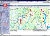
The object of the analysis is to calculate the theoretical potential for small hydro power plants. The method uses national digital datasets (existing hydro power, digital elevation model, river-network, runoff maps, digital hydrography) and digital cost functions were manually checked against known resources and plans. The results were approved and presented on an interactive internet map.
Features & Advantages
- Reduces the manual work needed for traditional resource mapping, but the results have to be manually controlled by experts against existing plans. A number of datasets are needed to ensure reliable results. Preparation of this kind of datasets is resource.
- The method does not take environmental questions into consideration, but potential found in protected areas could easily be deleted.

Technology Owner
Norwegian Water Resources and Energy Directorate (NVE) — www.nve.no
COUNTRY
Norway
RETURN TO SMALL HYDRO INNOVATIVE TECHNOLOGIES HOME PAGE